Summary
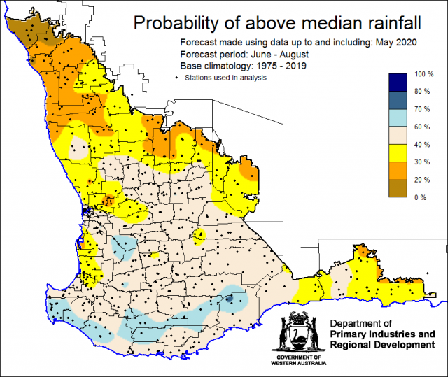
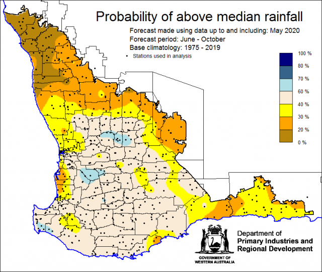
The Department of Primary Industries and Regional Development’s (DPIRD) Statistical Seasonal Forecast (SSF) outlook for winter, June to August and June to October 2020 is indicating less than a 40% probability of above median rainfall for the Central West, Central Wheatbelt, South East Coastal and parts of the Lower West Districts of the South West Land Division. Neutral odds apply elsewhere.
- For winter June to August 2020, the SSF is indicating less than a 40% chance of exceeding median rainfall for the Central West, Central Wheatbelt and South East Coastal Districts, with neutral odds elsewhere. The most probable rainfall decile map indicates decile 2-3 for Central West, Central Wheatbelt, South East Coastal and parts of the Lower West Districts. Decile 4-7 rainfall is likely elsewhere. Predictive skill based on June conditions is poor to good (50 -75% consistent).
- For June to October, the SSF is indicating less than a 40% chance of above median rainfall for parts of the Central West, Central Wheatbelt and South East Coastal Districts, neutral odds elsewhere. The most probable rainfall decile map indicates decile 2-3 for the Central West, Central Wheatbelt and South East Coastal Districts. Decile 4-7 rainfall is forecast for the remainder of the SWLD. Predictive skill based on June conditions is poor to good (50 -75% consistent).
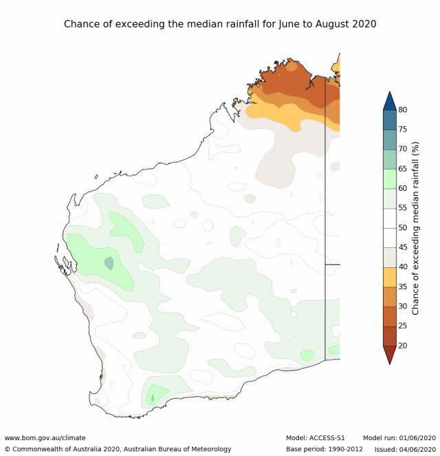
- The Bureau of Meteorology’s current seasonal outlook is indicating close to neutral chances (45-60%) of exceeding median rainfall for winter, June to August 2020. Predictive skill is poor to good (45-75% consistent). The longer-term outlook for July to September, is for wetter conditions. Predictive skill is 50-65% consistent.
- Temperature outlooks for winter, June to August 2020, from the Bureau indicate a 50-65% chance of above average day-time maxima (skill 55-65%) and a 50-70% chance of above average night-time minima (skill 50-65%) for the SWLD.
- May rainfall was mostly below average across cropping regions, although some parts in the south and around Merredin received decile 8-9 rainfall. Autumn, March to May, rainfall was below average in the north and only near average in the south-west corner. May maximum temperatures were average to above average. May minimum temperatures were below average to average.
- The early part of winter rainfall for the SWLD may be drier than normal due to a positive Southern Annular Mode that is predicted to persist though June.
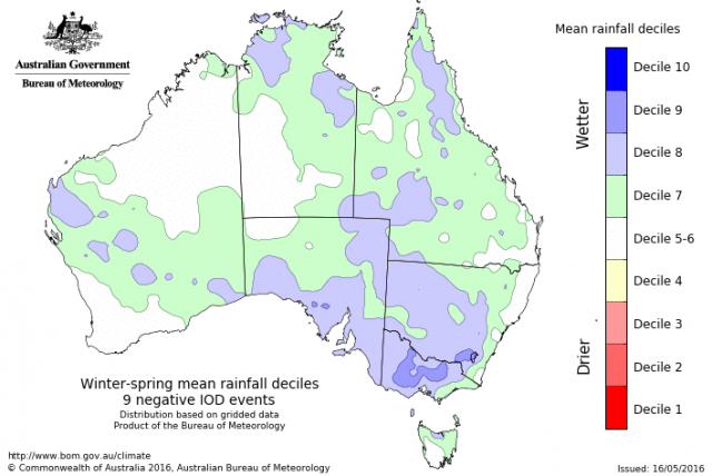
- Winter and spring rainfall may be influenced by a negative Indian Ocean Dipole (IOD). This is forecast to develop from late July and persisting until October. A negative IOD typically brings above average winter–spring rainfall to southern Australia. However, for south western WA some negative IOD years have been drier than normal, such as 2010 and 2016.
Three Month Outlook for the south-west of Western Australia
Statistical Seasonal Forecasting (SSF)
DPIRD’s Statistical Seasonal Forecast (SSF) system uses historical relationships between global sea surface temperature and sea level pressure with rainfall in south-west Australia to produce forecasts of rainfall for the coming months. Users can click on any station indicated on the map for location-specific forecast information from the Seasonal Climate Information [1] web page.
For winter June to August 2020, the SSF is indicating less than a 40% chance of exceeding median rainfall for the Central West, Central Wheatbelt and South East Coastal Districts, with neutral odds elsewhere. The most probable rainfall decile map indicates decile 2-3 for Central West, Central Wheatbelt and South East Coastal Districts. Decile 4-7 is expected elsewhere. Predictive skill based on June conditions is poor to good (50 -75% consistent).
 [2]
[2]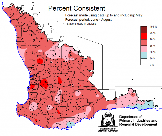 [3]
[3]Bureau of Meteorology seasonal climate outlook
The Bureau of Meteorology's climate forecast system for monthly and seasonal climate outlooks is the Australian Community Climate Earth-System Simulator – Seasonal (ACCESS–S [4]). It is a dynamical (physics-based) forecast modelling system and is a collaboration between the Bureau of Meteorology and the UK Meteorological Office.
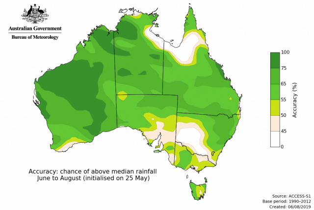
The Bureau of Meteorology’s current seasonal outlook is indicating close to neutral chances (45-60%) of exceeding median rainfall for winter, June to August 2020. Predictive skill is poor to good (45-75% consistent). These probabilties have weakened from outlooks produced in May. The longer-term outlook for July to September, is for higher chances at 55-70% with predictive skill at 50-65% consistent.
Temperature outlooks for winter, June to August 2020, from the Bureau indicate a 50-65% chance of above average day-time maxima (skill 55-65%) and a 50-70% chance of above average night-time minima (skill 50-65%) for the SWLD.
Looking at other climate model outlooks for winter rainfall over southern WA, the majority have either neutral chances of exceeding median rainfall or only weak shifts towards wetter or drier conditions.
SSF Forecast for May to October
For June to October, the SSF is indicating less than a 40% chance of above median rainfall for parts of the Central West, Central Wheatbelt and South East Coastal Districts, with neutral odds elsewhere. The most probable rainfall decile map indicates decile 2-3 for the Central West, Central Wheatbelt and South East Coastal Districts. Decile 4-7 rainfall is forecast for the remainder of the SWLD. Predictive skill based on June conditions is poor to good (50 -75% consistent).
 [8]
[8]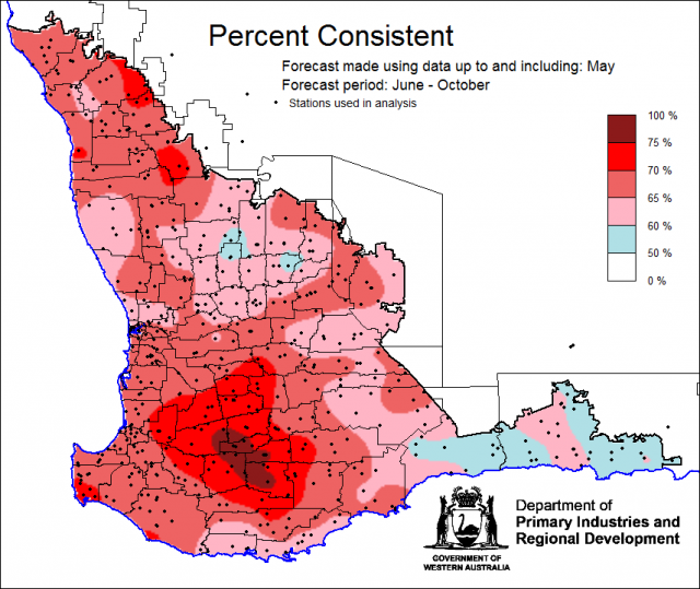 [9]
[9]Recent climate
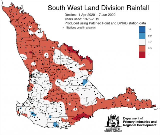
May rainfall was generally below average across cropping regions, though some parts in the south and around Merredin received decile 8-9 rainfall. Autumn, March to May, rainfall was below average in the north and only near average in the south-west corner. Autumn rainfall in the SWLD has been below average since 2017. May maximum temperatures were average to above average. May minimum temperatures were below average to average. Rainfall from 1 April to date has generally been below average in the SWLD.
In May, the atmospheric pressure [11] [11]was higher than normal over the SWLD.
Indian Ocean sea surface temperatures [12] (SST) north-west of Western Australia have been warmer than average, though they have cooled recently. While SSTs remain warmer than average, their influence on Australian rainfall has been waning. The July to September 2020, SST forecast by the Bureau of Meteorology [13] indicates SSTs are likely to remain warm north of WA.
The Southern Annular Mode (SAM), also known as the Antarctic Oscillation (AAO), describes the north–south movement of the westerly wind belt that circles Antarctica, dominating the middle to higher latitudes of the southern hemisphere. The Southern Annular Mode (SAM) is currently positive and is forecast to be remain positive in June. During winter, a positive SAM typically means less rainfall for SWLD.
The Indian Ocean Dipole (IOD) is currently neutral. Four out of six international climate models surveyed by the Bureau suggest the development of a negative IOD by the end of July, to last through to October. Note that these models have low skill in forecasting IOD at this time of the year. Winter-spring rainfall in the SWLD has been on average decile 5-6 for the past nine negative IOD events. However, not all negative IOD events have brought rain to the SWLD; 2010 and 2016 were both negative IOD years.
The El Niño–Southern Oscillation (ENSO) is likely to remain neutral over winter, some models are indicating a possible La Niña developing in late spring. For further information, see the Bureau of Meteorology’s ENSO Wrap Up [15].
The table below gives a summary of past month and three-month South West Land Division (SWLD) climate conditions, and can indicate what is likely to occur in the near future if climate conditions follow the current pattern.
| Climate Indicator | Past month | Past 3 months |
|---|---|---|
| SWLD Rainfall [16] | Average to Below Average | Mixed |
| SWLD Mean Temperature [17] | Average | Above Average |
| SWLD atmospheric pressure [11] | Above Average | Near Normal |
| Indian Ocean Sea surface temperature [18] | Warmer | Warmer |
| El Niño/Southern Oscillation [15] (ENSO) | Neutral | Neutral |
| Indian Ocean Dipole [19] (IOD) | Neutral | Neutral |
| Southern Annular Mode [20] (SAM) | Positive | Positive |

