Grain production in Western Australia map

Page last updated: Wednesday, 27 May 2020 - 3:37pm

Please note: This content may be out of date and is currently under review.

Department of Primary Industries and Regional Development supports the growth of Western Australia's agrifood sector in four key areas: markets, productivity, profitability and people.

A range of food and fibre education resources including classroom activities, information and tools have been compiled for use by teachers to access at the Teaching Resources section of this website. The Grain Production in Western Australia map is an additional educational resource for schools to access.

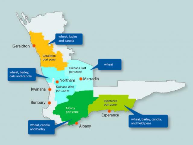
Map of port zones and grain growing regions in Western Australia
Western Australian grain growing regions and port zones

The above map shows the grain production area of Western Australia which is divided into five port zones according to the port to which grain is transported for export. The main grains produced in each port zone are shown and summarised in the table below.

Grain production in each port zone of Western Australia
Port zone Main centre Grains produced
Geraldton Geraldton wheat, canola, lupins
Kwinana West Northam wheat, canola, barley, oats,
Kwinana East Merredin wheat
Albany Albany wheat, canola, barley
Esperance Esperance wheat, canola, barley, field peas

Download a printable version of the map from the 'Documents' section at the right-hand side of this page.

Author

Megan Abrahams