Summary
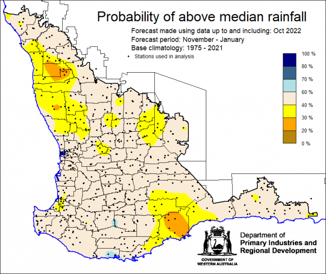
The Department of Primary Industries and Regional Development’s (DPIRD) Statistical Seasonal Forecast (SSF) outlook for November 2022 to January 2023, is indicating mostly neutral (40-60%) probability of above median rainfall for the majority of the South West Land Division.
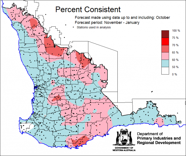
- For November 2022 to January 2023, the SSF forecast is indicating mostly neutral (40-60%) probability of above median rainfall for the majority of the South West Land Division. Less than 40% probability for part of the Central West, Central Wheatbelt, Great Southern and South Coastal Forecast districts. The most likely decile range map is indicating decile 2-3 for the majority of the SWLD. Skill is mostly poor at 50 to 70 % consistent.
- The Bureau of Meteorology’s seasonal outlook for November 2022 to January 2023 is indicating 35-65% chance of exceeding median rainfall for the SWLD, with moderate to good skill (55-75%). The current longer-term outlook (at time of writing) for December 2022 to February 2023 is 30-50% chance of exceeding median rainfall with mostly moderate skill (45-65%).
- Temperature outlooks for November 2022 to January 2023, from the Bureau indicate a 20-65% chance of above average day-time maxima, with the lower chances for Great Southern, South Coastal and South East Coastal forecast districts. Skill is good at 75-100%. For night-time minima for the SWLD, the Bureau is indicating 30-65% chance of exceeding above average temperatures, with the higher chances for Central West, Lower West, South West and South Coastal forecast districts. Skill is good at 75-100%.
- October rainfall was above average with reports of hail. October maximum temperatures were below average to very much below average. Minimum temperatures were below average.
- In the next couple of months, the warmer sea surface temperatures north of Australia increases the likelihood of tropical cyclones developing. In La Niña years, the first Australian tropical cyclone to make land fall is about 3 weeks earlier than in a neutral ENSO year. Later spring and summer rainfall in the SWLD are usually caused by isolated thunderstorms and tropical cyclones and are therefore harder to (long-lead) forecast, than winter rainfall which are mostly from westerly frontal systems.
Three Month Outlook for the south-west of Western Australia
Statistical Seasonal Forecasting (SSF)
DPIRD’s Statistical Seasonal Forecast (SSF) system uses historical relationships between global sea surface temperature and sea level pressure with rainfall in south-west Australia to produce forecasts of rainfall for the coming months. Users can click on any station indicated on the map for location-specific forecast information from DPIRD’s Seasonal Climate Information pages.
For November 2022 to January 2023, the SSF forecast is indicating mostly neutral (40-60%) probability of above median rainfall for the majority of the South West Land Division. Less than 40% probability for part of the Central West, Central Wheatbelt, Great Southern and South Coastal Forecast districts. The most likely decile range map is indicating decile 2-3 for the majority of the SWLD. Skill is mostly poor at 50 to 70 % consistent.


