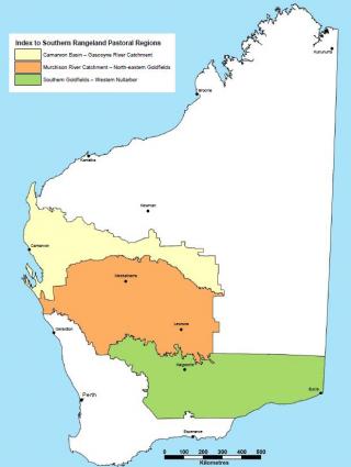
The southern rangelands region covered in this guide
These pasture condition guides cover about 815,000 square kilometres of the rangelands of Western Australia (see Figure 1), of which the major land uses are: pastoral lease (60%); unallocated Crown land (24%); and conservation estate (12%) in 2020. The area has been the subject of 9 inventory and condition surveys mainly undertaken by this department. The guides take into account 402 of the land systems described in rangeland surveys and 272 habitat (or vegetation) types.
Using these guides
We recommend that you read the Introduction to pastures in the Southern Rangelands first for a full introduction to the pasture condition guide.
The pasture guides can be used as a reference for pasture condition assessments and as a training guide for pastoral station staff and others interested in the productivity and maintenance of rangeland plants and pasture communities. By tracking pasture condition, managers can assess the influence of management and set goals for rangeland condition.
Managers can use these guides to assess pasture condition on the listed pasture types in the southern rangelands. A pasture type is a distinctive mix of plant species, soil type and landscape position. The southern rangelands include the Gascoyne, Murchison and Goldfields-Nullarbor regional areas (Figure 1).
Pilbara pasture types on the northern boundary of the Carnarvon Basin – Gascoyne River Catchment area will overlap with southern rangeland pastures – also see the Pasture condition and management guide for the Pilbara if you are managing pastures in that overlap area.
Pasture condition is an important factor affecting animal production and is a useful indicator of ecologically sustainable management (a requirement of the Land Administration Act 1997) the sustainability of production and
Southern rangelands pasture types with links to condition and management information
Pasture types in the southern rangelands can be classified into 3 main groups: Chenopods, shrubs, grasses (Table 1).
Pasture groups |
| Occurrence |
|
|---|---|---|---|
Chenopods | Gascoyne1 | Murchison2 | Goldfields-Nullarbor3 |
| Bluebush pastures | Yes | Yes | Yes |
| Eucalypt chenopod pastures | x | Yes | Yes |
| Greenstone stony plain pastures | x | Yes | Yes |
| Mixed chenopod shrub plain pastures | Yes | Yes | Yes |
| x | x | Yes | |
| Riparian association pastures | Yes | Yes | Yes |
| Saltbush pastures | Yes | Yes | Yes |
| Samphire pastures | Yes | Yes | Yes |
| Snakewood pastures | Yes | Yes | x |
| Stony mixed chenopod pastures | Yes | Yes | Yes |
Shrubs | |||
| Acacia hardpan pastures | Yes | Yes | Yes |
| Acacia–cassia short grass forb pastures | Yes | Yes | Yes |
| Currant bush mixed shrub pastures | Yes | x | x |
| x | Yes | Yes | |
| Heath | Yes | Yes | Yes |
| Sandplain acacia pastures | Yes | Yes | Yes |
| Sandy granitic acacia shrub pastures | x | Yes | Yes |
| Stony acacia–cassia–eremophila pastures | Yes | Yes | Yes |
Grasses | |||
| Buffel grass pastures | Yes | ?4 | ? |
| Hard spinifex pastures | Yes | Yes | Yes |
| Soft spinifex pastures | Yes | x | x |
| Spear grass/wallaby grass pastures | x | x | Yes |
| Wanderrie grass pastures | Yes | Yes | Yes |
1 Includes the Gascoyne catchment and Carnarvon Basin survey areas
2 Includes the Murchison River catchment, Lower Murchison River catchment and the Wiluna–Meekatharra survey areas, plus most of Sandstone–Yalgoo–Paynes Find and north–eastern Goldfields survey areas
3 Includes the southern Goldfields and Nullarbor survey areas, plus part of Sandstone–Yalgoo–Paynes Find and north–eastern Goldfields survey areas
4 Not yet significant or widespread in extent, but isolated stands and individuals are present, mostly confined to run on areas and road verges.
For more information
Contact one of the staff listed below.


