Summary
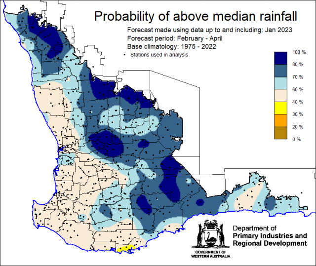
The Department of Primary Industries and Regional Development’s (DPIRD) Statistical Seasonal Forecast (SSF) outlook for February to April 2023, is indicating greater than 60% probability of above median rainfall for the majority of the South West Land Division, although skill is very low this time of the year.
- For February to April 2023, the SSF forecast is indicating greater than 60% probability of above median rainfall for the majority of the South West Land Division. Neutral (40-60%) probability for parts of the Central West, Lower West, Great Southern, South West, South Coastal and South East Coastal forecast districts. The most likely decile range map is indicating decile 8-10 for the majority of the South West Land Division, decile 4-7 in other places. Skill is mostly poor at 50 to 70 % consistent.
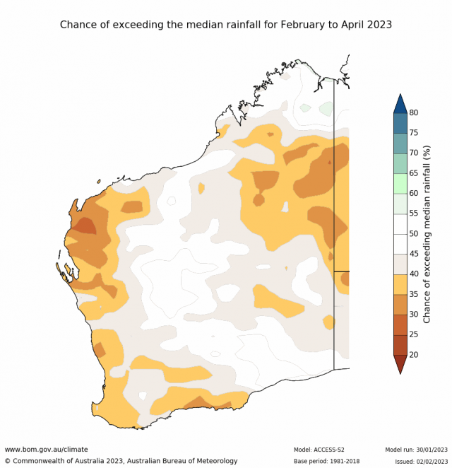
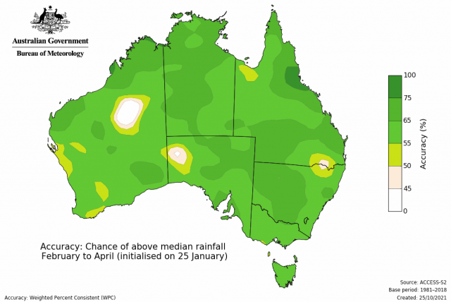
- The Bureau of Meteorology’s seasonal outlook for February to April 2023 is indicating 25-45% chance of exceeding median rainfall for the SWLD, with poor to moderate skill (55-65%). The current longer-term outlook (at time of writing) for March to May 2023 is less than 45% chance of exceeding median rainfall with mostly poor skill (45-65%).
- Temperature outlooks for February to April 2023, from the Bureau indicate a 65-80% chance of above average day-time maxima. Skill is moderate 65-75%. For night-time minima for the SWLD, the Bureau is indicating 50-80% chance of exceeding above average temperatures, with the higher chances along the coast. Skill is moderate at 55-75%.
- January rainfall was below average to average. January maximum temperatures were average to above average, below average for South Coastal and South East Coastal forecast districts. Minimum temperatures were below average to average.
- The main climate driver influencing Australia rainfall is the La Niña in the Pacific, although it has little influence over rainfall in the SWLD. February to April, and March to May outlooks have lower skill than at other times of the year, due to the autumn ‘predictability barrier’ for forecasting ENSO.
Three Month Outlook for the South West Land Division
Statistical Seasonal Forecasting (SSF)
DPIRD’s Statistical Seasonal Forecast (SSF) system uses historical relationships between global sea surface temperature and sea level pressure with rainfall in south-west Australia to produce forecasts of rainfall for the coming months. Users can click on any station indicated on the map for location-specific forecast information from DPIRD’s Seasonal Climate Information pages.
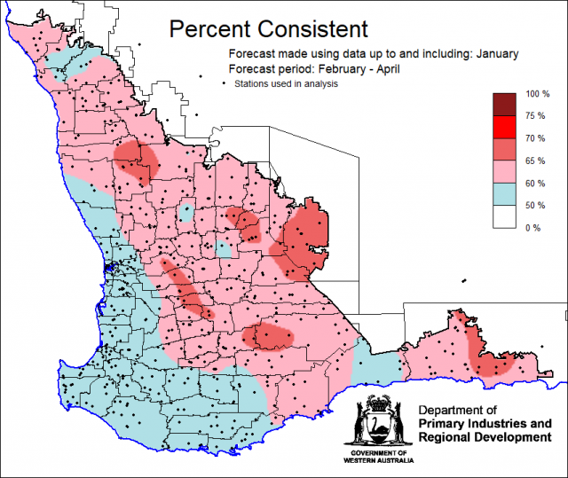
For February to April 2023, the SSF forecast is indicating greater than 60% probability of above median rainfall for the majority of the South West Land Division. Neutral (40-60%) probability for parts of the Central West, Lower West, Great Southern, South West, South Coastal and South East Coastal forecast districts. The most likely decile range map is indicating decile 8-10 for the majority of the South West Land Division, decile 4-7 in other places. Skill is mostly poor at 50 to 70 % consistent.
Bureau of Meteorology seasonal climate outlook
The Bureau of Meteorology's climate forecast system for monthly and seasonal climate outlooks is the Australian Community Climate Earth-System Simulator – Seasonal (ACCESS–S2). It is a dynamical (physics-based) forecast modelling system and is a collaboration between the Bureau of Meteorology and the United Kingdom Meteorological Office.
The Bureau of Meteorology’s seasonal outlook for February to April 2023 is indicating 25-45% chance of exceeding median rainfall for the SWLD, with poor to moderate skill (55-65%). The current longer-term outlook (at time of writing) for March to May 2023 is less than 45% chance of exceeding median rainfall with mostly poor skill (45-65%).
Temperature outlooks for February to April 2023, from the Bureau indicate a 65-80% chance of above average day-time maxima . Skill is moderate 65-75%. For night-time minima for the SWLD, the Bureau is indicating 50-80% chance of exceeding above average temperatures, with the higher chances along the coast. Skill is moderate at 55-75%.
Looking at other rainfall forecasting models, the majority of models are equally indicating neutral to below, and neutral chance of exceeding median rainfall for the SWLD for February to April 2023.

Recent climate
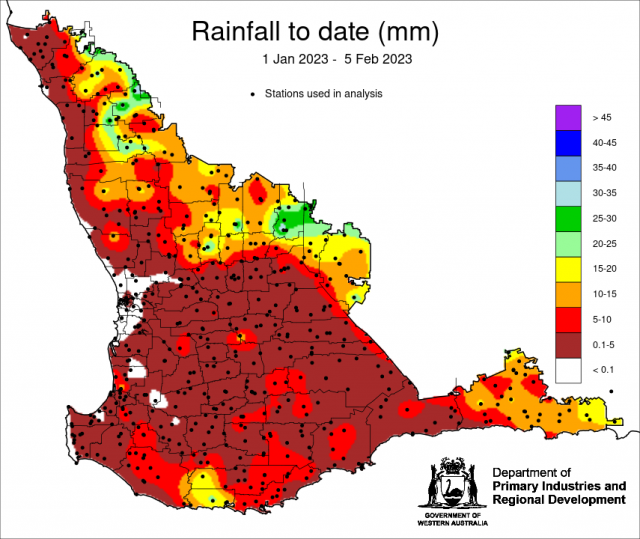
January rainfall was below average to average. January maximum temperatures were average to above average, below average for South Coastal and South East Coastal forecast districts. Minimum temperatures were below average to average. Since 1 January, Koorda has had 37.8 mm of rain from isolated thunderstorms.
In January the atmospheric pressure was near normal over the SWLD.
Sea surface temperatures are now average in northern Australia. The sea surface temperature outlook for February to March by the Bureau of Meteorology indicates SSTs will be normal to warm around Western Australia. Warmer temperatures marginally increase the likelihood of tropical cyclones developing.
The Indian Ocean Dipole (IOD) is neutral and has little influence on Australian climate while the monsoon trough is in the southern hemisphere (typically December to April). Two models (including the Bureau of Meteorology) are indicating the development of a positive IOD in June.
The Southern Annular Mode (SAM), also known as the Antarctic Oscillation (AAO), describes the north–south movement of the westerly wind belt that circles Antarctica, dominating the middle to higher latitudes of the southern hemisphere. The Southern Annular Mode (SAM) is currently positive and is likely to be positive until at least mid-March. SAM has no influence on rainfall in the SWLD in summer. For more information see the Bureau of Meteorology’s Climate Driver Update.
The La Niña continues in the tropical Pacific. ENSO events typically peak in late (southern hemisphere) summer and decay during the autumn; current outlooks indicate this La Niña may decay slightly earlier than usual (February). The Bureau of Meteorology is indicating an El Niño developing in June. However, as accuracy is generally lower for long-range ENSO forecasts made during summer, ENSO outlooks that extend past autumn should be viewed with caution.
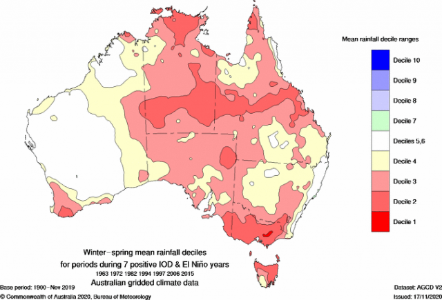
An El Nino together with a positive IOD, would mean reduced rainfall for the South West Land Division, as seen in the map below. Although, skill for these forecasts are currently poor, but are worth watching out for as the year progresses.
The table below gives a summary of past month and three-month South West Land Division (SWLD) climate conditions, and can indicate what is likely to occur in the near future if climate conditions follow the current pattern.
| Climate Indicator | Past month | Past 3 months |
|---|---|---|
| SWLD Rainfall | Average to below average | Mixed |
| SWLD Mean Temperature | Mixed | Below average to average |
| SWLD atmospheric pressure | Normal | Below normal |
| Indian Ocean Sea surface temperature | Warmer | Warmer |
| El Niño/Southern Oscillation (ENSO) | La Niña | La Niña |
| Indian Ocean Dipole (IOD) | Neutral | Neutral |
| Southern Annular Mode (SAM) | Positive | Positive |

